This month brings a tour of a small wreck with a big reputation on Scotland’s east coast – a trawler that sank in the 1990s. JOHN LIDDIARD leads the tour, illustration by MAX ELLIS.
HAVING FOUNDERED JUST A FEW MILES out from Lossiemouth, the steel-hulled trawler Unity is virtually the house reef. The seabed is at 24m, so the Unity is accessible to all divers who have progressed beyond basic open water qualifications.
As with the vast majority of the Moray Firth, there is no current or slack water to worry about, so the Unity can be dived at any state of the tide, either as a quick trip out for a single dive or as a convenient second dive on the way back in from a deeper wreck.
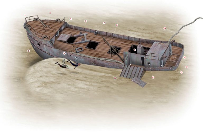
There is usually a buoy attached to the bow, so this is where our tour begins (1).

Or rather, this is where the real tour begins, because the first thing to look out for when diving the Unity are the famous Moray Firth dolphins, riding the bow wave of the dive-boat on the journey out from Lossiemouth.

Anyway, back to the wreck. The railing around the bow is mostly intact, and both the railing and the bow itself are covered in anemones. At 20m, this is the shallowest point of the wreck.
What little current there is concentrates a cloud of fish about the tip of the bow. Also centred here is an old tyre set as a fender – an arrangement not out of place on a working boat like the Unity, though it amazes me that old tyres are still used as fenders on far posher ships.
I suppose that any trendy modern purpose-built alternative would end up looking like an old tyre anyway.
Further back on the starboard side of the bow, the railings have collapsed inward. At the centre of the deck, a diagonally set square base (2) is the mounting point for a small anchor winch.
Behind this, just before the forecastle steps down to the main deck, a circular hole marks where the forward mast would have been.
Like many other fittings, the steps were removed when the Unity was stripped in Lossiemouth before the hull was towed to the breakers’ yard. Fortunately for us divers, the Unity foundered under tow, so the final breaking never happened.
Over the side of the bow and about level with the base from the anchor winch, each side of the forecastle is pierced by a small porthole (3), with another old tyre set as a fender at the back of the forecastle.
Behind the forecastle, stooped hatches lead back inside (4), though there is nothing to see other than accumulated silt.
The hatch cover from the first hold is slid forwards, leaving the hold open. The second hold is also open, with no sign of the associated hatch.
As in the forecastle, silt is beginning to accumulate in the holds, though ribs from the hull are still showing through.

A heavy H-shaped frame is set diagonally on the deck between these two holds (5), the base from part of the catch-sorting and processing machinery.
A set of three parallel pipes leads from here and out through the gunwale on the port side (6). Decaying ropes are tucked in beneath the gunwale most of the way aft.
The wreck is rolled slightly to port so that the port main deck is a metre or two closer to the seabed than the starboard side. Towards the aft of the main deck, this brings the port side almost level with the seabed.
Across the wreck on the starboard side, an engineer’s vice, similar to any that would be found in a home workshop, is welded to the starboard gunwale (7).
Continuing aft, the third and last hold is also open, with no sign of the hatch cover.
A tripod mast that has fallen across the deck hinders access to the hold (8). It would originally have stood against the front of the wheelhouse, with the two shorter legs bracing it against the wheelhouse roof.
The wheelhouse was removed so that the engine could be stripped from the hull, leaving a big hole where the wheelhouse and engine used to be (9).

Dropping down inside the vacated engine space, a generator is still mounted low on the starboard side.
Behind the engine space, an intact section of cabin roof spans the hull, though leaving space for access forward and aft on the starboard side.
Partitioned off at the port side is the perennial diver’s favourite sight, a lavatory, with a small porthole to provide light and ventilation (10).

The cabin forward of this lavatory on the port side was still intact when the Unity sank, but the outer wall and roof have now fallen outward and come to rest on the seabed (11).
Behind the cabins, the spreaders for the trawl stand on either side (12), solid pillars with the tops canted out and pulley blocks hanging from the ends.
The centre of the aft deck is marked by the outline from where the base of the trawl winch would have been bolted in place (13).
The stern has sunk into the sand further than the bow, but the list to port leaves just enough space to get beneath the starboard side (14). As would be expected on a ship stripped prior to breaking, the propeller had been removed before the Unity sank.

A little way forward, and the vent for the engine-cooling water is exposed just above the seabed.
At the final point on our tour, although unlikely to be the end of the dive, a 10cm rope is tied to the starboard spreader and floats off for several metres before breaking (15).
Already covered in big plumose anemones, I suspect that eventually the weight of accumulated silt and marine life will bring this down to the seabed.
The Unity is only a small wreck, so even a no-stop dive will give time to swim the length of the wreck and back to the bow with plenty to spare.
With no current to worry about, ascent is easy via the buoyline at the bow.
Thanks to Simon Few, Bill Ruck and Tim Walsh.
STILL CATCHING FISH
UNITY, trawler. BUILT 1975, SUNK 1994
SHE WAS A FINE EXAMPLE of a Peterhead trawler, but despite her fine landings record, in the end she ran out of time, writes Kendall McDonald.
Unity was her name, PD209 her number. Twenty-four metres long and of 75 tons, she was a 600hp fishing trawler, built at Peterhead and owned by David Foreman. Lossiemouth on the eastern edge of Moray Firth was her home port.
In 1994 her time was up and she was decommissioned. Her engine was taken out in Lossiemouth Harbour, then she was taken under tow to end her days as scrap at Invergordon in the Cromarty Firth. But she never made it.
She had hardly started on that last voyage when the tow snapped and she foundered a few miles out to become one of the most popular dives in the area. Locals regard the Unity as theirs, a sort of “home wreck” for all the divers for miles around.
TOUR GUIDE

GETTING THERE: Take the A941 from Elgin to Lossiemouth. Once there follow the waterfront along the west side of the river, past the first part of the harbour, then left to the second part of the harbour. Top Cat is berthed at the end of the pontoon on the north side of the basin.
HOW TO FIND IT: The Unity lies bow to the north-east. GPS position is 57 45.304N, 003 13.326W (degrees, minutes and decimals).
TIDES: There is little current at any state of the tide.
DIVING & AIR: Moray Diving, Top Cat, skipper Bill Ruck, 01309 690421 or 07775 802963.
ACCOMMODATION: Aberdeen & Grampian Tourist Board, Elgin office, 01343 542666
QUALIFICATIONS: Suitable for PADI Advanced Open Water/BSAC Sport Diver or equivalent.
LAUNCHING: RIBs can be launched in the harbour at Lossiemouth.
FURTHER INFORMATION: Admiralty Chart 115, Moray Firth. Admiralty Chart 222, Buckie to Fraserburgh. Admiralty Chart 223, Dunrobin Point to Buckie. Ordnance Survey Map 28, Elgin and Dufftown.
PROS: Convenient for Lossiemouth, with plenty of marine life.
CONS: A small wreck, so it can get rather crowded.
DEPTH: -20m, 20m-35m
PDF version of The Unity Wreck Tour
Appeared in DIVER October 2007