This freighter was an early U-boat victim during World War Two, and the wreck off Portland Bill in Dorset makes for a good dive – but it’s important to get your timing right, says JOHN LIDDIARD. Illustration by MAX ELLIS
TO SEE ALL OF THIS MONTH’S WRECK in one dive, you have to move fast, even on a neap tide. Located on the edge of the Shambles Bank, to the east of Portland Bill, slack water arrives and departs in a rush on the Elena R.
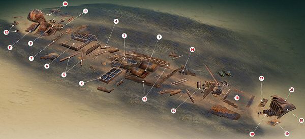
The wreck lies with its bow to the south-east so, as the tide slacks off, descending the shotline the stern will be to the left and the starboard side of the wreck will be slightly sheltered from the current.
The wreck is fairly well broken, and mostly covered in a bank of broken mussel shells. The boilers (1) are big enough to show on an echo-sounder, and are a good target for the shot at 24m, but are more than half-buried in the bank. There are plenty of breaks in the boilers, and in the nooks and crannies lurk several conger eels.

Across the wreck and just off the starboard side, the frame from the engine-room skylight and ventilator (2) lies upside-down and filled with mussel shells.

Aft of the two boilers, the engine is broken and buried beneath a debris of deck-grating, plates, ribs and pipes with resident congers. Just some odds and ends of the engine poke out towards the aft edge of the debris, including the top of the thrust-bearing (3).
Crossing an area of shell that fills the area of the first hold aft, a tubular section of mast (4) lies across the wreck and slightly to port. Next to the mast are the upright remains of the bulkhead from between the holds, and towards the starboard side you’ll see a pair of beams from the cargo derricks (5) associated with the mast.
The aftmost hold is slightly more intact, with three sides of the hold coaming (6) floating on the bank of shells, and a section of the port side of the hull alongside. The wreck is then crossed by another bulkhead (7) that stands just clear of the shells.
Our route now concentrates on the port side of the wreck, because this is the way the stern has fallen. A long cargo-winch (8) has bent spindles, but is upright on its mounting-plate and would have spanned the beam of the ship before falling slightly to port.
Slightly inside the stern, the tail-end of the propeller-shaft disappears into a box-section of tunnel (9).
Staying on the port side, above the deck of the stern, a pair of bollards floats on the seabed. A little further out, a screw-threaded part of the steering mechanism (10) lies flat, and brass collars have been polished by the shifting seabed.

Below the stern, the seabed has been scoured slightly to 27m. The rudder (11) is still roughly in place, though detached from its hinge. The propeller must have been salvaged. The last notable items of wreckage are more bollards (12) a couple of metres off the stern.

By now the tide will be starting to turn. For the other half of the dive, on the forward half of the wreck, the quickest way back to the boilers is to follow the port side, which will now offer some shelter.
Level with the boilers, the side of the hull (13) stands perhaps a metre off the seabed. The longitudinal bulkhead inside would have contained a coal-bunker.

Continuing forward on the port side, conical lobster-pots (14) are heaped in the corner where the stoke-hold bulkhead meets the first hold forward.
Between the forward holds, the foot of a mast (15) still stands upright with three winches arranged about it, the beam from a cargo-derrick lying across the top.
The forward hold again has a relatively intact coaming (16). The next item of note is a heavy deck-plate supporting a pair of hollow conical structures (17). This would originally have been the other way up, and have guided the anchor-chains from the anchor-winch into the chain-box.

The bow has fallen to starboard, and the anchor-winch (18) rests propped against the deck beams. Just out from this, an isolated pair of bollards lie alone on the seabed. Then, forward, another pair of bollards are still attached to an upside-down deck-plate (19).
Inside the bow, both anchor hawse-pipes are in place (20). The section of hull with the starboard hawse-hole has fallen to the seabed. Beneath the bow, the seabed is deeply scoured down to rock at 30m.

Following the stem and then the keel round below the bow, the last item on our tour is a pile of anchor-chain among the derelict remains of the chain-box (21).
With the tide now building, this is definitely not a dive on which to attempt to ascend on the shotline. A delayed SMB is essential with a drifting decompression.
EARLY MERCHANT VICTIM
ELENA R, cargo steamer. BUILT 1917, SUNK 1939
ANYONE SEEING THAT the 4526-ton Greek merchant steamer Elena R had been mined and sunk on 22 November, 1939, near the Shambles Light Vessel off Portland Bill, might assume that Germany started its war on merchant shipping much earlier than was generally believed.
In fact, as the Elena R moved up-Channel with a full cargo of wheat from Rosario in Argentina to be delivered to Antwerp, one of the Kriegsmarine’s UC-class of minelaying U-boats moved out. The Elena R then struck one of the mines the U-boat had left behind, writes Kendall McDonald.
The truth is that the mines were left not for merchant shipping but for British warships out of Portsmouth and other naval ports. The Shambles Lightship was to warn all shipping of the shallows of the Shambles Bank. The Elena R was warned, went wide, and ran straight into the minefield.
The mine exploded on the port side of her bow.
It took nearly 20 minutes for the ship to start sinking, which gave the 24 crewmen time to take to their own boats and get to the light vessel. The Weymouth lifeboat arrived on the scene a little later, and ferried the 24 men from lightship to shore at Weymouth.
The Elena R was not the vessel’s name when she was built in 1917 by the Newport News Shipbuilding & Drydock Co at Newport News in Virginia, USA.
It launched her as the Munindies, 370ft long with a beam of 53ft and a draught of nearly 20ft.
The power to drive her single screw came from a three-cylinder triple-expansion engine with two boilers, which gave her 471hp.
She was soon bought by a Greek shipping syndicate, which renamed her Elena R, after the wife of its head. It sailed her under the Greek flag, with her home port in the capital island of Siros, one of the 200 Greek islands that make up the Cyclades in the Aegean Sea.
At first she was used to carry cargoes all around the Mediterranean, and she saw out World War One without incident. Then her voyages grew longer and longer, and when WW2 began she was a regular on the run between Europe and South America.
The wreck was swept during 1959, and divers of that time reported that it was being engulfed by the Shambles Bank.

TOUR GUIDE
GETTING THERE: For Weymouth, follow the A37 or A354 to Dorchester, then the A354 to Weymouth and on to Portland via Chesil Beach, turning left for the old Castletown dockyard as the road starts to climb the hill to Portland. Breakwater Diving is located at the Aqua Sport hotel, on the left as you enter Castletown.
HOW TO FIND IT: The GPS co-ordinates are 50 30.209 N, 002 20.686W (degrees, minutes and decimals). The wreck lies bow to the south-east.
TIDES: The Elena R lies very close to the Shambles bank, with complicated tides. The wreck should consequently be dived only two-and-a-half hours before high water Portland, and as close to neap tides as possible.
DIVING & AIR: Scimitar Diving, 07765 326728.
ACCOMMODATION: Aqua Hotel, 01305 860269.
QUALIFICATIONS: PADI Advanced Open Water or BSAC Sports Diver. This dive is at an excellent depth to enable divers to get the best from nitrox, but slack water may not last long enough for you to do so!
LAUNCHING: Slips are available at Weymouth and Portland Harbour. Launch fees are payable.
FURTHER INFORMATION: Admiralty Chart 2610, Bill of Portland to Anvil Point. Ordnance Survey Map 194, Dorchester, Weymouth & Surrounding Area. Dive Dorset, by John & Vicki Hinchcliffe. WW1 Channel Wrecks, by Neil Maw. Shipwreck Index of the British Isles, Volume 1, Richard & Bridget Larn. Weymouth tourist information, 01305 785747.
PROS: Visibility is often quite good, close to the Shambles bank.
CONS: Proximity to the Shambles bank limits slackwater options.
DEPTH RANGE: 20-35m
Thanks to Smudge.
Appeared in DIVER December 2009