The first images from an ROV scan of the WW1 warship HMS Hampshire have been released by the University of the Highlands & Islands Archaeology Institute.
The 11,000-tonne, 144m armoured cruiser had taken part in the Battle of Jutland shortly before her sinking 100 years ago. She was heading for Archangel when she hit a mine laid by the German U-boat U75 and sank on 5 June, 1916.
Only 12 of the 655 crew survived. Among the seven passengers lost was Field Marshal Lord Kitchener, the Secretary of State for War, who was being taken with his staff to a meeting with the Russian Tsar, Nicholas II.
The wreck is designated under the Protection of Military Remains Act, though illegal salvage work was carried out in the early 1980s. It lies around 60m deep off Orkney’s west coast, and the first archaeological assessment was carried out on 25 May by the Archaeology Institute in partnership with Seatronics, Teledyne RESON, Roving Eye Enterprises and Triscom Marine.
The institute said that the survey, the start of a continuing programme, had provided new data and insights into the mine damage at the bow and the impact of salvage activity and natural deterioration.
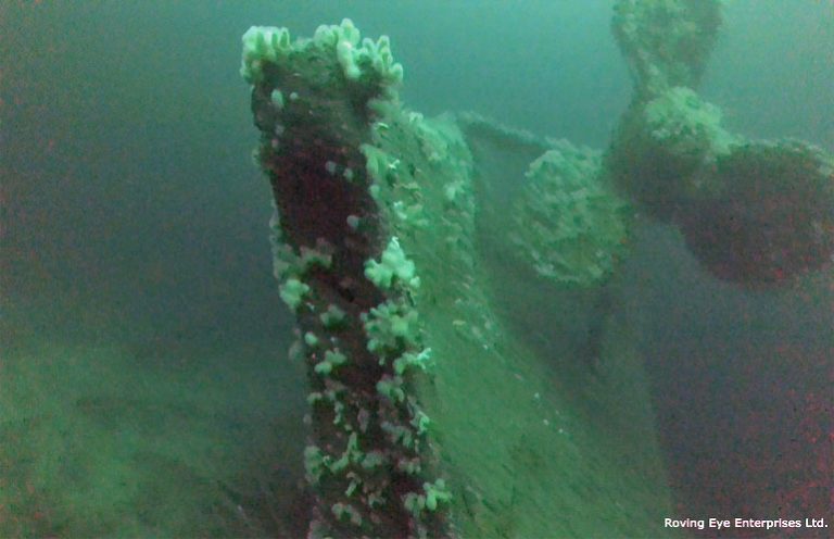
The survey confirmed that HMS Hampshire had capsized and lay with its hull inverted, reported the institute. The compressed superstructure was buried in soft silt, and hull damage was noted the length of the vessel, exposing internal elements including torpedo-tubes and machinery.
Breech-loading 6in Mk VII guns were noted up to 30m from the main body of the wreck – these could have been dispersed during the sinking or during salvaging.
“It was a real privilege to be involved with this project,” said Keith Bichan of Roving Eye Enterprises. “I am an Orcadian who has had an ROV business in Orkney for nearly 20 years and the HMS Hampshire was a wreck I always wanted to visit, due to its importance to First World War history, and the mystery and controversy that still surrounds it.”
Further survey work using the Seatronics Predator ROV is planned.