It’s a double-header this month, as JOHN LIDDIARD dives two vessels that became wrecks on the same evening off north Wales 136 years ago. The illustrations are by MAX ELLIS
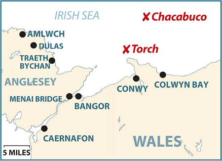
THE TWO SMALL WRECKS in our double tour this month have a neat connection, because on the stormy night of 1 March, 1873, the steamship Torch collided with the sailing ship Chacabuco, and both sank. As you’ll see from the history panel, the Chacabuco went down within minutes while the Torch remained afloat for several hours, but because the Torch is the more complex wreck, I will deal with this one first.
The Steamship Torch
The Chacabuco, as we will see, represents the end of the era of sailing ships, but the Torch represents almost the beginning of iron steamships, and so provides an interesting contrast.
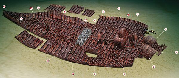
Our tour begins at the boiler (1), though you may not at first recognise it as such, because this is an 1860-era low-pressure box boiler, not the cylindrical Scotch boiler that became standard later in the century. Its top is the shallowest part of the wreck, rising to 13m from a general depth of 18m on the broken hull.
Behind the boiler is an equally basic two-cylinder compound steam engine (2), upright with intact cylinders.
From the engine, the propeller-shaft disappears beneath a section of the starboard side of the hull that has fallen inwards (3). This leads to a small section of keel and the stern (4), fallen to port. The iron propeller is still on the shaft, with two blades standing a little above the silt.
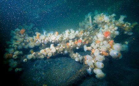
The port side of the hull at the stern (5) has also fallen inwards. Everywhere else on the wreck, however, the sides of the hull have fallen outwards.
Level with the back of the boiler are a pair of bollards (6), upright on their mounting-plate, but fallen as the wooden deck decayed and the sides of the hull splayed out.
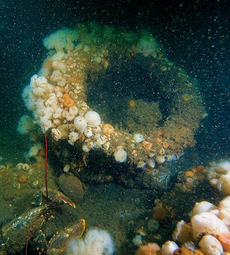
Next, we pass a big iron ring, one of a pair (18). It looks to have fallen here rather than being originally attached, so could have been part of a deck fitting. Perhaps it was a fairlead for a mooring rope, as it is close to the bollards.
Towards the centre-line, a winch (7) lies almost across the front of the boiler. Forward of this is a big section of tube (8) that may have been the funnel, or perhaps part of a water tank.
Back towards the port side of the hull, a small section remains standing, with a corresponding cut-out in the plates from the side of the hull that has fallen to the seabed. Next to this is a tubular iron frame of unknown purpose (9).
Continuing forward along the line where the port side of the hull has fallen away, a little further on we pass another pair of bollards (10).
Just inside of these are the remains of a transverse bulkhead (11) with “rocks” piled against it. This is part of the general cargo that just happens to have concreted into what looks like a pile of rocks.
Forward of the bulkhead, the hold area is empty, so any cargo in this part of the wreck has either been salvaged or was the sort of stuff that floated off or decayed.
Lying on one side, diagonally across the line of the keel, is a second winch (12). Both winches are fairly simple spindles with a large drum on one end and a small drum on the other, far less complex than cargo winches found on more recent wrecks.
This one may also have doubled for raising the anchor, as there is no sign of a dedicated anchor-winch further forward.
Off to the port side is a single boat derrick fallen to the floor of the hold, and a rectangular structure of wood and iron layers sandwiched together (13).
I have no idea what this is. A mast foot for a wooden mast on an iron ship? If so, why so complicated? Perhaps it was part of the cargo.
Continuing forward, the hull begins to narrow noticeably (14), with braces across holding the lower parts of the side of the hull intact.
The sides taper in finely until we reach the stem of the bow (15). The overall shape reminds me more of the long bow of some paddle-steamers than that of a cargo-carrying steamship. Perhaps the Torch’s hull design was developed from that of a paddle-steamer, before propeller-driven ships had really developed their own shape and character.
Returning aft, the starboard side of the hull (16) has not collapsed as much as the port side, and sections stand upright as far as the bulkhead (17).
Finally, as we get to the boiler, another iron ring rests across the hull ribs (18). The boiler or engine both rise to 13m, from where a delayed SMB can be launched.
DEPTH RANGE: -20m
SAILING SHIP CHACABUCO
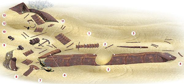
There is not much of this sailing ship standing above the seabed, so it is the sort of wreck where a shotline is dropped into the middle of whatever echo can be found, rather than attempting to hook onto a specific major structure. When I dived the wreck, the shot had caught on a section of the starboard side of the hull (1) at 28m.
The Torch struck the starboard quarter of the Chacabuco, so it is hardly surprising that it capsized to starboard, leaving the port side of the hull uppermost (2). Heading aft on the deck side of the hull, scattered spars and ribs protrude from the sand, with a sizeable section of mast (3) close to the stern.
Actually at the stern, the rudder (4) is slightly skewed from the wreck.
Heading forwards along the hull, it’s hard to see bare metal through the sheer mass of plumose anemones. A break in the hull (5) corresponds approximately to where the Torch would have struck the starboard side, but this is on the wrong side of the hull, so would be secondary damage from where the hull has broken since the Chacabuco sank.
We now come to where the bow has broken away, a more complicated area of wreckage. What appears to be a section of mast (6) rests half out of the sand, though given the proximity to the bow, this may have been part of the bowsprit. Behind it are a set of bands that would once have stepped sections of mast together.
Our route continues along the keel, past a strangely shaped piece of wreckage (7). As far as I can tell, this was nothing more significant than a fragment of the hull.
Next we come to a section of the bow (8) standing upright. It contains the anchor hawse-pipes. The scour here is the deepest part of the wreck, at 31m. Be careful here.
A trawl-net has been lost against the bow, and while it’s easy enough to avoid in good visibility, it could be a hazard if vis is poor.
The trawl-net is mostly buried in the sand, and leads to the also partly buried trawl-beam (9). Just uphill from this is the anchor-winch (10), and a long-shafted Admiralty-pattern anchor (11).
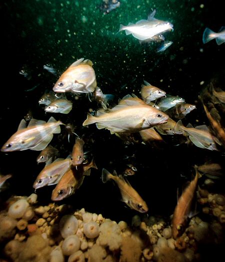
Following the ridge of the banked sand off to the left, a small hatch-coaming from the bow deck sticks out of the sand (12), then finally another section of the bow rises 2m from the seabed at an angle to form a pyramid-shaped cave (13). This is the highest point of the wreck at 27m, so attracts the densest shoal of pouting.
For a no-stop dive, returning to the shotline to ascend should be OK, but as soon as the dive gets into decompression it would be best to send up a delayed SMB and drift.

TOUR GUIDE
GETTING THERE: Follow the A55 across north Wales to Anglesey and across the Menai Bridge. To get to Amlwch, take the A5025. To reach Menai Bridge, take the first slip road and turn right to the town. Turn towards the waterfront by the newsagent and post office opposite HSBC, and then to the pontoon by the harbour office.
HOW TO FIND IT: GPS co-ordinates for the Chacabuco are 53 27.681 N, 003 47.541 W, and for the Torch 53 21.870 N 003 52.890 W (both in degrees, minutes and decimals).
TIDES: Slack water comes one hour before high water Liverpool for both wrecks, and one hour before low water Liverpool in the case of the Chacabuco but 45 minutes before low water Liverpool for the Torch. Chris Holden advises that on neap tides the Torch is better dived just off slack, as this will help to clear any silt kicked up.
DIVING & AIR : Julie-Anne operates out of Amlwch, 01407 831210. Quest Diving Charters operates from Menai Bridge, 01248 716923, Chester BSAC.
ACCOMMODATION: Taldrwst Bach Farm, Dulas, has a static caravan and limited camping, and can provide air for divers staying on the site, 01407 832220. It is a bit out of the way, so look up LL68 9RG on Google Maps.
QUALIFICATIONS: Chacabuco’s maximum depth of 30m means PADI Advanced Open Water or BSAC Sports Diver and is an ideal depth to benefit from nitrox. Torch is suitable for entry-level qualifications, as the depth is 18m on a low-water slack, but current and possible low visibility requires a reasonably confident beginner.
LAUNCHING: Slip and beach launching at Conwy, Colwyn Bay and Traeth Bychan.
FURTHER INFORMATION: Admiralty Chart 1978, Approaches to Liverpool. Admiralty Chart 1977, Holyhead to Great Ormes Head. Ordnance Survey Map 114, Anglesey. Anglesey Wrecks & Reefs by Andy Shears and Scott Waterman. The Essential Underwater Guide to North Wales, Volume 2, South Stack to Colwyn Bay by Chris Holden. Wrecks of Liverpool Bay by Chris Michael. Anglesey tourist information.
PROS: Both wrecks are a nice size and complexity for no-stop dives at their respective depths.
CONS: Strong current, short slack water and possible low visibility, especially on the Torch.
DEPTH RANGE: 20-35m
Appeared in DIVER October 2009
