
By Josh Richards
Josh Richards and the Soggy Wombats embark on a quest to discover what lies beyond a tantalising gap in the photogrammetry data for Pines Cave in Australia’s cave-diving Mecca – the Mt Gambier region
The Question That Started It All
It all started with a simple question: ‘What the hell is that empty spot?’ Will had just wrapped up dozens of dives in Pines Cave to collect photogrammetry data and was now in the painstaking process of turning tens of thousands of still images into a high-resolution 3D model using Agisoft Metashape. Our eventual goal? A game-changing map to support divers exploring one of Mount Gambier’s most-renowned cave sites.
But as Will proudly sent me screenshots of the model’s point cloud, all I could see was a massive gap in the data on the northern side of the Crazy Czech Room (CCR) – the end of the known tunnel.
The CCR is a 20-metre-wide chamber formed by a roof collapse directly beneath a road used by forestry trucks. Discovered in 2002 by two visiting Czech divers, it’s long marked the end of Pines Cave. Reaching it means weaving through a rock maze to 34m, jumping to the Surprise Tunnel, swimming over 70 metres at depth, before ascending a rockpile to the chamber at 14m. Will had scanned the room slowly and comprehensively, so with his experience the modelling should have been flawless.
We had perfect data from the siltier South-West side of the CCR – an area I once thought held the most promise for an extension. But the model revealed only blind boulders and impenetrable dolomite. That made the unexplained void on the north side even more intriguing. If the GoPros weren’t seeing a wall… maybe there wasn’t a wall?
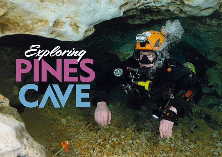
In places written off as ‘already explored’, the Soggy Wombats will continue to find new ways on by using science and technology to discover what others missed


Did you know?
Cave diving is a unique and challenging activity, combining the thrill of scuba diving with the exploration of underwater caves. It offers access to fascinating geological features, rare fauna, and unique ecosystems, but also presents big dangers.

Did you know?
CCR (Closed Circuit Rebreather) cave diving offers unique advantages like extended bottom time and potentially better gas management in cave environments, but also presents significant risks and demands rigorous training and planning.
Science, Technology and the Soggy Wombats
There’s a saying in cave exploration: you haven’t really checked a cave until you’ve touched the back of every wall. And Will’s photogrammetry data was showing us a new way to do just that – by identifying where the wall data was missing altogether.
We’d seen this pattern before. A year earlier in Iddlebiddy Cave, the model had holes in a jumbled rockpile. Only later on a slower and more-careful scan did I spot a hole in the roof which led to a previously unknown surface lake, and eventually to 100 metres of new tunnel we’d name A New Hope. Will couldn’t get back to Pines for a few months, so I decided to check the northern CCR gap myself. It took just one dive to confirm the gaps in the data had real-world counterparts.
Exploring the Hidden Passage
Dropping to the far side of the rockpile, I found a low, silty flattener hidden behind loose rocks that concealed it from the main chamber. The silt cleared unusually rapidly too, hinting at something rare for Mount Gambier – flow. Peering ahead, I spotted a stark white wall beyond the flattener. I squeezed forward and found a second flattener at a sharp left angle – far too tight for my current drysuit and twin 12s set-up. So I reached for my secret weapon – a GoPro and fill light mounted on a selfie stick.

No way to slow the descent – I crashed into silt at 34m and kicked up a visibility-killing cloud
I twisted the camera into the gap, letting it roll blind. As I pulled it back, I noticed the silt I’d knocked from the roof was moving toward me. That’s when it hit me – there was flow pulling it through, and there had to be something very big pushing water into that second flattener. Back at the surface, we pulled the footage and sure enough the GoPro had captured a jumbled room — big enough to turn around in, and possibly big enough to go on.
A month later, using stage cylinders, a wetsuit and a streamlined wing, I wriggled through the second flattener -soon dubbed The Gadi Gap. The room beyond felt full of promise, but most passages turned into deadends.
Still, I kept returning, slowly wearing down the restriction until I could squeeze through wearing a drysuit and 12s.
On my final dive into the rockpile, I swam to the deepest point and saw… nothing – just more collapsed boulders and silt. I locked off my reel and began turning to leave when I caught a shadow that didn’t belong. There was a basketball-sized rock perched on a silt mound, and behind it a dark, smooth wall of phreatic limestone. And more importantly, flow.
I jammed the selfie stick through the tight hole, not daring to hope too much. But the footage revealed more tunnel – definitely tight, but enough to turn around in.


The next day I was back for the big push. The restriction was tighter than the Gadi Gap, and I had to unclip one of my cylinders to fit through. Beyond was a narrow vertical passage dropping straight down into blackness. No way to slow the descent – I crashed into silt at 34m and kicked up a visibility-killing cloud.
But near the roof, the water was crystal clear – another sign of flow. Swimming up, I spotted a tunnel leading south. Still cautious, I assumed it would end quickly. But as I swam, the passage kept going. Up and over, I found myself in a massive room – and another rockpile, deeper and further than anyone had ever ventured.
I tied off and turned back, still unsure if anyone would believe the find. The next dive I came armed with my other secret weapon – an Insta360 X4. I’d been testing it for cavern footage, and now it was perfect for this moment. Better yet, we could process the X4’s spherical frames in Metashape to produce a 3D model of the new tunnel too. The resolution from the 360-camera was lower than Will’s rig, but the agility it offered in tight caves was unmatched. The result was a model that not only captured the new tunnel, but showed that the end was within 15 metres of Stinging Nettle – a nearby cave long suspected to connect to Pines.
A New Discovery Beneath Mount Gambier
Now we had strong evidence that it did: a drainage hole in Stinging Nettle’s southern side points straight toward our new tunnel. I don’t know if we’ll find the connection between the two caves, but we never would’ve gotten this far without Will’s photogrammetry or asking ‘What the hell is that empty spot?’. We might use huge lights and selfie sticks, but our cameras aren’t (just) for cool dive videos – we film to collect scientific data so we can map known spaces, spot gaps, and then safely explore the unknown. In places written off as ‘already explored’, the Soggy Wombats will continue to find new ways on by using science and technology to discover what others missed.
Frequently Asked Questions
What is photogrammetry in cave diving?
Photogrammetry is the process of using thousands of still images to build accurate 3D models of underwater environments. It helps divers map caves and identify new areas to explore safely.
Where is Pines Cave located?
Pines Cave is one of the renowned dive sites in Mount Gambier, South Australia — a global hotspot for cave and sinkhole diving.
Who are the Soggy Wombats?
The Soggy Wombats are a team of Australian cave divers known for using science, technology, and 3D modelling to explore and map complex underwater cave systems.
What is the Crazy Czech Room (CCR)?
The CCR is a 20-metre-wide chamber at the end of Pines Cave, formed by a roof collapse beneath a forestry road. It was first discovered by Czech divers in 2002.
How was The Gadi Gap discovered?
The Gadi Gap was identified after a gap appeared in the photogrammetry data of the CCR’s northern wall. It led to a new passage and chamber, possibly connecting to Stinging Nettle Cave.
This article was originally published in Scuba Diver Magazine
Subscribe today with promo code DIVE1 — enjoy 12 months for just £1!