The Balkan nation of Montenegro, which has a 300km eastern Adriatic coastline, is keen to start attracting scuba-diving tourists – and as part of that process has just opened its first underwater archaeology research unit.
The Laboratory of Maritime Archaeology (LabMA) is part of the University of Montenegro’s Centre for Research, Innovation & Entrepreneurship, based in the coastal town of Kotor. Its declared mission is to investigate, document, interpret and promote maritime archaeological and underwater cultural heritage sites of all eras, support policy development and boost public awareness of Montenegro’s underwater resources.
Also read: Free app samples Adriatic wreck dives
“Archaeological finds within the Montenegrin basin, although insufficiently explored, are very diverse,” promises LabMA. “There is ample evidence of shipwreck remains ranging from Hellenistic and Roman merchant ships, and vessels from the Middle Ages, to those that were used in the previous century mainly for military purposes.”

“Their resting places have to be identified, while the already identified remains of maritime and underwater cultural heritage have to be acknowledged as an immeasurable contribution to the attractiveness of the Montenegrin coast.”
LabMA has pledged to advocate implementing UNESCO 2001 Convention on the Protection of Underwater Cultural Heritage provisions while promoting sustainable tourism.
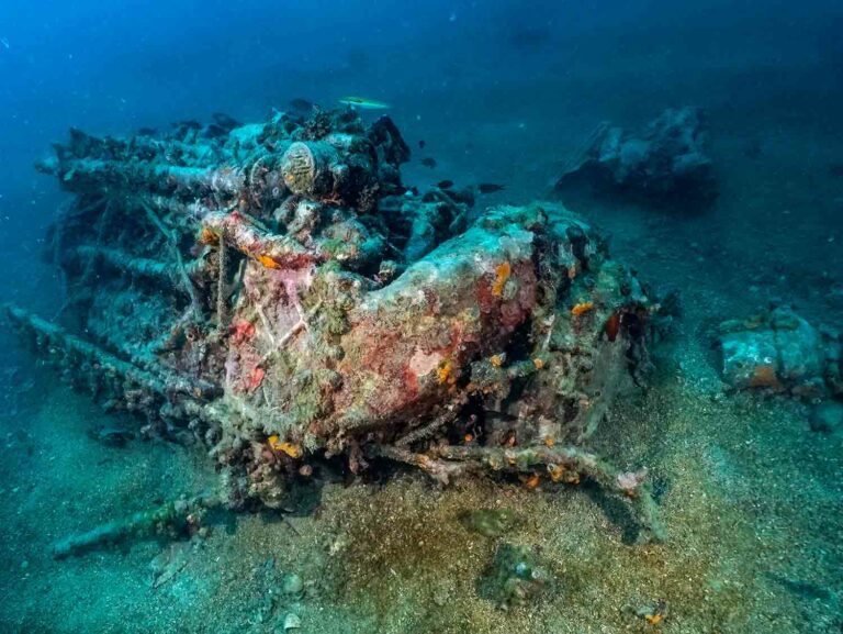
Examples of existing 20th-century shipwrecks that the laboratory feels are likely to appeal to international divers include the French WW1 destroyer Dague, mined near the port of Bar, where it lies 18m deep; and the Austro-Hungarian collier Tihany, sunk after running aground in 1917 and lying at 45m in Boka Kotorska Bay.

In the same bay is a Supermarine Spitfire MK IX Trop (tropical version) wreck – in 1944 the aircraft was hit by AA gunfire during an attack and crashed into the sea, where it lies on sand at 32m. The pilot escaped but was captured by German forces. Dive-centres in the town of Herceg Novi can arrange diving on the Spitfire and Tihany wreck-sites, while the Dague can be dived from Bar.
“Five dive-centres are operating on the coast by PADI/SSI standards, and quality of service is emerging from what was previously a military CMAS style,” the head of LabMA, maritime archaeologist Darko Kovacevic, told Divernet.
Formerly with Heritage Malta, Kovacevic became involved with Montenegro through the EU-funded Wrecks4All project, which aims to develop tourism based on the country’s underwater heritage sites.

Wrecks4All uses virtual and augmented reality techniques to render sites more accessible to both diving and non-diving tourists, and has plans to produce nine VR and AR tours as well as a virtual map of underwater heritage trails in Kotor.
“As an outcome of the project, I succeeded in establishing the Laboratory of Maritime Archaeology at the university,” said Kovacevic, who regards its opening as the first move in “establishing a stakeholders’ network to institutionalise dive-tourism development” in Montenegro.
According to an independent study in 2019, few official steps had been taken at that time to either assess or protect Montenegro’s underwater sites: “One 15th-century wreck located in the Bay of Kotor has achieved legal protection, but no further steps have been taken, and it is thought that it is still being looted, with no way to monitor the site or enforce the protection,” it reported.

LabMA’s comprehensive list of objectives leads off with complete seabed-mapping of Montenegrin territorial waters and identification of underwater cultural heritage. It also plans to process underwater archaeological material from private collections, track missing material at home and abroad, and create a database and online portal of underwater archaeological sites.
The laboratory has four permanent staff and its own 8.5m dive-boat along with scuba-diving, underwater photogrammetry, laser-scanning data-acquisition and remote-sensing equipment, 3D printers and computers.
“The mapping of territorial waters would certainly take some time – I believe four to five years if everything goes well,” said Kovacevic. “A part of the waters is already mapped and there are sites to be identified, and targets to be verified.
“LabMA would use different resources for mapping by multibeam and sidescan sonar, but mostly existing resources in collaboration with the hydrographic unit of the Institute of Meteorology & Seismology, which owns a survey vessel.” More on LabMA can be found here.
Also on Divernet: Who Disturbed Ancient Med Amphora Site?, Diver Retrieves Crusader Sword In Med, Divers Investigate ‘World’s Oldest Shipwreck’
I did 2 shore dives in Montenegro in 2013 – I really hope things have improved. All I saw was the rubbish thrown from the cliffs into the sea, it wasn’t even interesting rubbish. The dive shop was happy to rent me kit and send me in off the beach on my own – which should have been a red flag – but I persuaded a local in the shop to come with me! I should have just walked away and saved my money.