A first-of-its-kind study has revealed that Marine Protected Areas (MPAs) are succeeding in curbing industrial fishing activity – but only those that count among the world’s best-enforced, and make full use of aids such as satellite tracking and artificial intelligence.
The peer-reviewed research is confidently entitled Little-To-No Industrial Fishing Occurs In Fully And Highly Protected Marine Areas. Satellite imagery combined with AI technology can detect those previously untraceable vessels responsible for illegal fishing, it states, raising the question of why any area designated an MPA in the 21st century should remain a “paper park”.
According to the report, 78.5% of the 1,380 MPAs chosen for study had no commercial fishing activity. Of the MPAs in which satellite imagery did detect illegal fishing activity, 82% averaged fewer than than 24 hours of fishing per calendar year.

Strongly protected MPAs had, on average, nine times fewer fishing vessels per square kilometre than unprotected coastal areas.
MPAs designated as strictly protected but with significant fishing activity included those in the Chagos Marine Reserve, South Georgia & the South Sandwich Islands and the Great Barrier Reef Marine Park (combined with the Great Barrier Reef Coast Marine Park), each with around 900 hours of fishing a year.
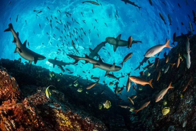
“Because strictly protected marine areas discourage illegal fishing, fishes are far more abundant within their boundaries; they produce many more babies, and help replenish surrounding areas,” notes study co-author Enric Sala, National Geographic explorer in residence and founder of Pristine Seas. “In other words, the fishing industry benefits from following the rules.”

Spillover of fish
Other research has shown that spillover of fish and invertebrates from MPAs can increase catches outside their boundaries by between 12 and 18%.
“Illegal fishing takes place in areas of the ocean set aside for protection, but using satellites we have found – for the first time ever – that the level of protection determines how much risk industrial fishers are willing to take on,” says Sala.
Illegal fishing jeopardises both the health of ocean ecosystems and the economic stability of the fishing industry, according to the study. Strictly protected MPAs restore marine life within their boundaries, improve local fishing, provide jobs and economic benefits, and build resilience against a warming ocean.
In those MPAs that are only minimally or lightly protected, the benefits virtually disappear.

“The ocean is no longer too big to watch. With cutting-edge satellites and AI, we’re making illegal fishing visible and proving that strong marine protections work,” says study co-author and Pristine Seas scientist Juan Mayorga.
To reach their conclusions, the researchers analysed five billion vessel positions from the Automatic Identification System (AIS), a GPS-based safety signal transmitted by many industrial fishing vessels.
They paired this data with satellite images generated by Synthetic Aperture Radar (SAR), which can detect vessels whatever the weather or light conditions.
Combining the datasets with the use of AI models developed by Global Fishing Watch allowed the researchers to detect most fishing vessels over 15m long, including ‘dark’ vessels that avoid broadcasting their location.

The full picture
“No single dataset can solve the challenge of monitoring fishing activity at sea; each has its blind spots,” says Mayorga. “But when we combine them, their power emerges.
“By fusing AIS tracking with satellite radar imagery and AI, we are now much closer to the full picture of human activity across the ocean.
“That’s especially important in the crown jewels of the ocean – the world’s most strongly protected areas – where the stakes for enforcement and biodiversity are highest.”

AIS data missed almost 90% of SAR-based fishing vessel detections within the MPAs, say the authors, whereas the new methodology offers a powerful way to assess fishing compliance and bridge blind spots in current monitoring methods.
“By using satellites to track fishing-vessels, countries can predict the locations of illegal activities and target patrol efforts, saving both manpower and money,” concludes study lead author Prof Jennifer Raynor of the University of Wisconsin-Madison. The research article is published in the journal Science.
Also on Divernet: Most marine-protection measures are not working, Nice 30×30 pledges ‘a drop in the bucket’, Hard-hitting Attenborough film condemns MPA trawling, How to make billions – by protecting scuba hotspots